Blada.com
lundi 15 juin

Boîtes aux lettres
Courrier des lecteurs
Petites annonces
Emploi / Formation
Covoiturage
Infos citoyennes
Infos citoyennes
25/03/20
Opération de régularisation foncière de Maripasoula
 La vaste opération de régularisation foncière pilotée par l’EPFA Guyane avec la commune de Maripasoula est enclenchée pour dynamiser le centre bourg.
90 % des habitants du bourg de Maripasoula n’ont pas de titre de propriété. La signature des deux premiers actes de vente le 9 mars dernier vient couronner quatre ans de collaboration étroite entrel’EPFA Guyane et la commune de Maripasoula à travers une convention de coopération public-public. Lancée en avril 2016, sur un sujet toujours délicat, la régularisation foncière d’occupants sans titre, cette Régularisation Foncière de Masse des Occupants Sans Titre - RFMOST - est le préalable pour assurer la faisabilité d’un plan-guide, ou la maîtrise du foncier est primordiale. Une vingtaine de parcelles déjà bornées pourra aussi faire l’objet de cession avant la fin de l’année. Le projet de revitalisation vise à accompagner la mutation d’un village rural en bord de fleuve vers une polarité administrative, sanitaire et commerciale, en lui conférant une structure urbaine cohérente.
Pour Denis Girou, directeur général de l’EPFA Guyane, « A terme, la réussite de cette démarche innovante de régularisation va conditionner la réussite du projet de réorganisation du bourg et de développement du territoire de Maripasoula. Il s’agit de donner une autre vie à la ville ».
Pour Serge Anelli, maire de Maripasoula « Cette démarche s’inscrit dans une stratégie cohérente d’aménagement et de restructuration du territoire pour favoriser le développement des équipements publics, la construction de logements et redynamiser l’offre économique. Actuellement, l’habitat spontané n’est pas relié aux réseaux, les équipements sont dispersés et les espaces publics et privés pas tous délimités. ».
Maripasoula, une identité unique, une diversité de paysages à respecter dans le plan guide
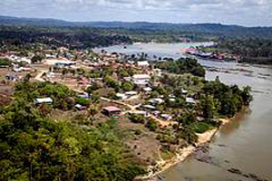 Frontalière du Suriname et du Brésil, Mari pasoula est un carrefour culturel, réunissant amérindiens, bushinengues, créoles,
européens, brésiliens, haïtiens et surinamais. La commune est située à 240 km de Cayenne, accessible seulement par voie
aérienne et par le fleuve Maroni. La ville compte 13.000 habitants sur un territoire d’une fois et demie celle de la région Île-de France . Plus de 90 % de sa surface fait partie du Parc amazonien de Guyane.
Son identité est liée à la proximité de la forêt et du fleuve auxquels les habitants sont très attachés. Pour repenser l’organisation du bourg sur tous ses aspects, le plan guide favorisera une approche globale transversale et parfois «technique» de l’urbanisation et le plan de paysage permettra d’apporter une vision plus sensible à cet aménagement.
Une convention public-public, innovante entre la commune et l’EPFA Guyane
Elle permet de mutualiser les ressources pour mettre en oeuvre la régularisation foncière de façon transversale. Elle implique de coordonner l’action sur des aspects divers de développement territorial (définition de la trame urbaine et structuration du parcellaire, études), foncier et technique (suivi des bornages), social (accompagnement des ménages), administratif et juridique (animation, rédaction des actes de cession).
En termes d’outils d’amélioration de l’habitat, dans un contexte atypique - occupants sans titre, croissance démographique, économie informelle, diversité culturelle, dispositifs de droit commun parfois difficiles à mettre en œuvre - l’enjeu du réaménagement de la commune repose en partie sur la capacité à mobiliser des outils plus novateurs. L’aide encadrée à l’auto-réhabilitation ou à l’auto-construction par exemple en se basant sur les savoir-faire des habitants est envisagée.
Deux zones AU (zones à urbaniser) sont réservées pour la conduite d’opérations structurées grâce à la régularisation foncière. En étant prévues dans le plan guide, leur aménagement pourra permettre de répondre aux besoins futurs de logements, tout en étant cohérent avec les ambitions de développement qualitatif du bourg.
Une intervention de l’EPFA Guyane en quatre étapes
La RFMOST a un double objectif : légaliser la possession des particuliers et matérialiser un Domaine Public communal adapté à la mutation du bourg.
L’EPFA Guyane a mis à disposition de la collectivité l’ensemble des moyens d’ingénierie technique et administrative nécessaires à l’accomplissement d’une intervention en 4 volets :
1. Le Développement territorial pour que les emprises publiques tiennent compte du projet urbain,
2. La Technique Foncière pour intégrer les parcelles au cadastre,
3. L’Accompagnement Social pour informer et concerter avec le public,
4. La Rédaction Administrative et Juridique pour formaliser et sécuriser les transactions entre la commune et les particuliers.
Avant de débuter l’opération, la commune a contracté un prêt de 1 million d’euros auprès de l’Agence Française de Développement (AFD) dans le but de préfinancer les prestations et les travaux nécessaires au programme RFMOST et mobilisé le Fond National d’Aménagement du Territoire FNADT (BOP113) pour subventionner le bornage des emprises publiques.
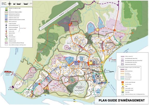
Un Plan Guide d’Aménagement co-construit avec les services publics essentiels et validé par la commune en octobre 2017
Il a posé les grands principes de la future organisation de la trame viaire et des espaces publics et le projet de délimitation a été soumis à la population avant sa validation définitive et son bornage pour enregistrement au cadastre.
La commune de Maripasoula a soutenu le projet de manière constante, en particulier via sa commission urbanisme.
L’EPFA Guyane a réalisé plus de 500 enquêtes foncières pour recenser et localiser les lots d’usage revendiqués par les particuliers afin d’avoir une première approche des occupations, des litiges entre riverains et de la capacité des ménages à intégrer la procédure mise en œuvre.
Compte tenu de la taille importante de la zone de travail, supérieure à 180 ha, il a été décidé de délimiter huit périmètres d’intervention et de commencer à agir sur deux quartiers les plus denses. Chaque particulier a été invité à constituer un dossier individuel d’acquisition et la vente des terrains aux particuliers permettra à la commune de recouvrir l’ensemble des frais et prestations nécessaires à la régularisation. Les sommes perçues assureront ainsi le remboursement du prêt contracté.
Afin de réduire les frais, un travail en profondeur a été mené avec le service du domaine, pour des évaluations de la valeur des terrains, atypiques en l'absence quasi totale de marché immobilier formel. Le Maire a été autorisé à authentifier les actes des ventes en la forme administrative.
Une démarche qui s’inscrit dans le cadre du programme expérimental de revitalisation du centre bourg : La ville a été désignée lauréate en 2015 suite à un appel à manifestation d’intérêt lancé par le Ministère du Logement, de l’Égalité des Territoires et de la Ruralité et piloté par l’agence nationale de l’habitat (ANAH), le Conseil Général de l’Égalité des Territoires (CGET), la Direction Générale Aménagement du Logement et de la Nature (DGALN) et Centre d’Etudes et d’Expertises sur les Risques, l’Environnement, la Mobilité et l’Aménagement (CEREMA).
Le projet en dates
2012 : Etude sur le foncier disponible à Maripasoula réalisée par l’Agence d’Urbanisme et de Développement de la Guyane (AUDeG)
2013 : Etude de préprogrammation de zones d’urbanisation future du bourg de Maripasoula par l’AUDeG
2016 : Validation du schéma d’aménagement régional (SAR) de la Guyane - Lancement d’une étude pré-opérationnelle «habitat» dans le centre-bourg - Signature de la convention public-public avec l’Etablissement public d’Aménagement de Guyane (EPAG)
2017: Signature de la convention Opération de Revitalisation du centre Bourg et de Développement du Territoire (ORCBDT) valant OPAH- Finalisation du plan guide d’aménagement - Lauréat de l’appel à projet «plan de paysage»
2018: PLU en cours de révision- Lancement du programme d’aménagement.
The vast land regularization operation led by EPFA French Guiana with the municipality of Maripasoula is underway to revitalize the town center.
90% of the inhabitants of the village of Maripasoula have no title deed. The signing of the first two deeds of sale on March 9 crowns four years of close collaboration between
EPFA French Guiana and the municipality of Maripasoula through a public-public cooperation agreement. Launched in April 2016, on a still delicate subject, the land regularization of untitled occupants, this Land Regularization of Untitled Occupants - RFMOST - is the prerequisite for ensuring the feasibility of a guide plan, or the control of land is essential. About twenty already limited plots may also be sold before the end of the year. The revitalization project aims to support the transformation of a rural village by the river towards an administrative, health and commercial polarity, by giving it a coherent urban structure.
According to Denis Girou, Director General of EPFA French Guiana, "Ultimately, the success of this innovative regularization process will condition the success of the project to reorganize the town and develop the territory of Maripasoula. It's about giving another life to the city. "
For Serge Anelli, mayor of Maripasoula "This approach is part of a coherent planning and restructuring strategy for the territory to promote the development of public facilities, the construction of housing and revitalize the economic offer. Currently, spontaneous housing is not connected to networks, facilities are scattered and not all public and private spaces are demarcated. "
Maripasoula, a unique identity, a diversity of landscapes to be respected in the guide plan
Bordering Suriname and Brazil, Maripasoula is a cultural crossroads, bringing together Native Americans, Bushinengues, Creoles, European, Brazilian, Haitian and Surinamese. The town is located 240 km from Cayenne, accessible only by road aerial and by the Maroni river. The city has 13,000 inhabitants on a territory one and a half times that of the Île-de-France region. More than 90% of its surface is part of the Amazonian Park of French Guiana.
Its identity is linked to the proximity of the forest and the river to which the inhabitants are very attached. To rethink the organization of the town on all its aspects, the guide plan will favor a global transversal and sometimes "technical" approach to urbanization and the landscape plan will make it possible to bring a more sensitive vision to this development.
An innovative public-public agreement between the municipality and EPFA French Guiana
It makes it possible to pool resources to implement land regularization across the board. It involves coordinating action on various aspects of territorial development (definition of the urban framework and structuring of the plot, studies), land and technical (monitoring of boundaries), social (support for households), administrative and legal (animation, drafting of transfer documents).
In terms of habitat improvement tools, in an atypical context - untitled occupants, demographic growth, informal economy, cultural diversity, common law mechanisms that are sometimes difficult to implement - the challenge of redeveloping the municipality is partly based on the ability to mobilize more innovative tools. Support for self-rehabilitation or self-construction, for example based on the skills of the inhabitants is envisaged.
Two AU zones (zones to be urbanized) are reserved for the conduct of structured operations thanks to land regularization. By being provided for in the guide plan, their development could meet future housing needs, while being consistent with the qualitative development ambitions of the town.
An intervention by EPFA French Guiana in four stages
The RFMOST has a double objective: to legalize the possession of individuals and to materialize a municipal public domain adapted to the transformation of the town.
The EPFA French Guiana has made available to the community all of the technical and administrative engineering resources necessary for the performance of an intervention in 4 parts:
1. Territorial development so that public rights-of-way take into account the urban project,
2. The Land Technique to integrate the plots into the cadastre,
3. Social Support to inform and consult with the public,
4. Administrative and Legal Writing to formalize and secure transactions between the municipality and individuals.
Before starting the operation, the municipality contracted a loan of 1 million euros from the French Development Agency (AFD) in order to pre-finance the services and works necessary for the RFMOST program and mobilized the National Fund 'FNADT Land Development (BOP113) to subsidize the demarcation of public rights-of-way.
A Development Guide Plan co-constructed with essential public services and approved by the municipality in October 2017
It laid down the main principles of the future organization of the road network and public spaces and the delimitation project was submitted to the population before its final validation and its demarcation for registration in the cadastre.
The municipality of Maripasoula has consistently supported the project, in particular through its town planning commission.
EPFA French Guiana has carried out more than 500 land surveys to identify and locate the use lots claimed by individuals in order to have a first approach to occupations, disputes between residents and the ability of households to integrate the procedure implemented.
Given the large size of the work area, over 180 ha, it was decided to delimit eight intervention areas and start working on two of the densest areas. Each individual has been invited to compile an individual acquisition file and the sale of land to individuals will allow the municipality to recover all of the costs and services necessary for regularization. The sums collected will thus ensure the repayment of the contracted loan.
In order to reduce costs, in-depth work was carried out with the domain service, for assessments of the value of land, atypical in the almost total absence of a formal real estate market. The Mayor was authorized to authenticate the acts of sales in administrative form.
An approach which is part of the experimental program to revitalize the town center: The town was designated the winner in 2015 following a call for expressions of interest launched by the Ministry of Housing, Land Equality and Rurality and managed by the National Housing Agency (ANAH), the General Council for the Equality of Territories (CGET), the General Directorate for Housing and Nature Development (DGALN) and Center for Studies and '' Expertise on Risks, Environment, Mobility and Planning (CEREMA).
The project in dates
2012: Study on the land available in Maripasoula carried out by the French Town Planning and Development Agency (AUDeG)
2013: Study of preprogramming of future urbanization areas in the town of Maripasoula by AUDeG
2016: Validation of the regional development plan (SAR) of French Guiana - Launch of a pre-operational “habitat” study in the town center - Signature of the public-public agreement with the public establishment of French Guiana (EPAG)
2017: Signature of the Operation Center for the Revitalization of the Bourg and Territory Development Agreement (ORCBDT) worth OPAH- Finalization of the development guide plan - Winner of the call for projects "landscape plan"
2018: PLU under revision - Launch of the development program.
Raccourcis


passer une petite annonce
passer une annonce de covoiturage


passer une annonce d’emploi


associations, postez vos actualités

participez au courrier des lecteurs


La Guyane c’est ici
La qualité de l’Air avec
ATMO

Photothèque

Lancements 2022
Vol 259 Ariane 5

